Sufi sahab, good to know about your upcoming trip!
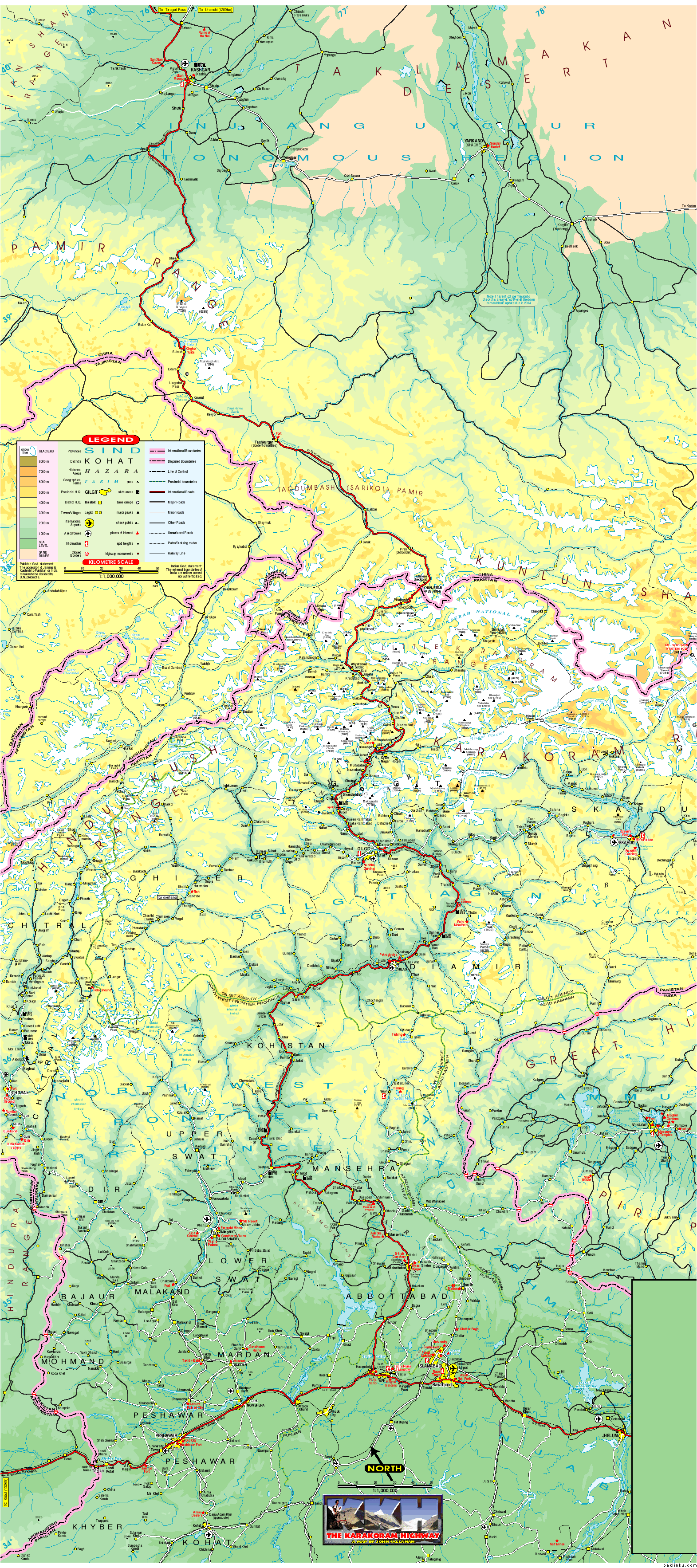
I’m uploading this map, which is actually KKH map, resolution is not good but that’s all I have…
I’ve a place-mark collection of google earth, which is called “Northern Pakistan Placemarks 1.7” just write this in google and it will come up with many links from where you can download it. It’s one of the best free maps available online.
We visited Skardu in 2008, I will summarize the rout we took, this may help you plan.
Before heading to Skardu, we drove to Chillas and stayed overnight. Shangrila Chillas is a good affordable place, the best thing about this hotel is its lawn overlooking River Indus. By the way you can buy a map from this hotel and they can also guide you to plan your trip and arrange vehicle.
From chillas you will drive towards gilgit, on the way you will cross raikot bridge (turning point towards fairy meadows). after 20-30 minutes drive from raikot, just before reaching “bunji” there is a road going right. now you have two options to reach Skardu, 1) leave KKH, turn right, cross the River Indus and go towards Astore. 2) keep going straight towards gilgit
If you choose to go via Astore, this will be the order of major places/ stops/ towns/ attractions… Astore ->Rama Lake → Chillam Chowki (entrance to Deosai National Park(straight/left), there is an army camp here, a road to right leads towards LoC) → Sheosar Lake → Bara Pani (here they have a temporary tent hotel (from july to sep only) → satpara lake → lower kachura (shangrila resorts) → upper kachora → and then long way back to KKH
If you take the other route, you will have to drive towards gilgit, cross Bunji Cantt, then Jaglot and there you will find junction of 3 mighty mountain ranges! This is where Karakoram, Hindukush and Himaliyas meet, ok drive a little further and you will find turning point for Skardu, here the river which you have been traveling with since Tha Kot (if you are traveling all the way on KKH) will split into two, River Indus will go right, Gilgit River will go straight up towards Gilgit, you will need to take right turn from here, cross “Ramghaat Bridge” and keep driving along side River Indus, all the way towards Skardu, this is a good 4-5 hours drive, now reverse the order of towns/ places from Upper Kachora to chillam chowki, and you will touch KKH again at Bunji… don’t forget to confirm all this by map, i may have messed up the names and their order : D
You can also directly fly to Skardu, this way you will be almost in the middle of this route which i’ve mentioned, to see upper/ lower kachora lakes and shangrila resorts, you will have to go north west, to see satpara/ deosai, you will to go south east. If you have too much time in skardu, you can hire a 4x4 and go to Shigar Valley, and then further upto Askole, which is the last village on this way, that is, the way to K2!!!
I’ve written almost everything I knew about skardu and surroundings, hope this will help…
Happy planning! best of luck