For the 2nd time this month, the major area of north america from midwest to northeast will be frozen in brutal cold weather.
And its late January. So why such rigid cold? Lets learn from NASA
Arctic Weather Plunges into North America
Desperately cold weather is now gripping the Midwest and Northern Plains of the United States, as well as interior Canada. The culprit is a familiar one: the polar vortex.
A large area of low pressure and extremely cold air usually swirls over the Arctic, with strong counter-clockwise winds that trap the cold around the Pole. But disturbances in the jet stream and the intrusion of warmer mid-latitude air masses can disturb this polar vortexand make it unstable, sending Arctic air south into middle latitudes.
That has been the case in late January 2019. Forecasters are predicting that air temperatures in parts of the continental United States will drop to their lowest levels since at least 1994, with the potential to break all-time record lows for January 30 and 31. With clear skies, steady winds, and snow cover on the ground, at least 90 million Americans could experience temperatures at or below zero degrees Fahrenheit (-18? Celsius), according to the U.S. National Weather Service (NWS).
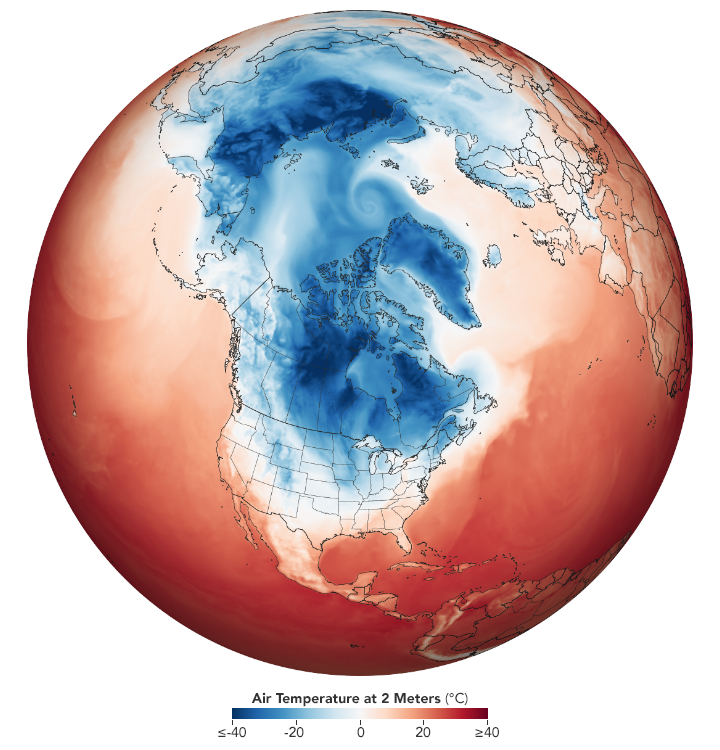
The map above shows air temperatures at 2 meters (around 6.5 feet above the ground) at 09:00 Universal Time (4 a.m. Eastern Standard Time) on January 29, 2019, as represented by the Goddard Earth Observing System Model, Version 5. GEOS-5 is a global atmospheric model that uses mathematical equations run through a supercomputer to represent physical processes.
The figure above is not a traditional forecast, but a reanalysis of model input fixed in time?a representation of atmospheric conditions near dawn on January 29, 2019. Measurements of temperature, moisture, wind speeds and directions, and other conditions are compiled from NASA satellites and other sources, and then added to the model to closely simulate observed reality. Note how some portions of the Arctic are close to the freezing point?significantly warmer than usual for the dark of mid-winter?while masses of cooler air plunge toward the interior of North America.
https://eoimages.gsfc.nasa.gov/images/imagerecords/144000/144489/greatlakes_tmo_2019027.jpg
January 27, 2019JPEG
You can almost feel that cold in this natural-color image, acquired on January 27, 2019, by the Moderate Resolution Imaging Spectroradiometer (MODIS) on NASA?s Terra satellite. Cloud streets and lake-effect snow stretch across the scene, as frigid Arctic winds blew over the Great Lakes.
NWS meteorologists predicted that steady northwest winds (10 to 20 miles per hour) were likely to add to the misery, causing dangerous wind chills below -40?F (-40?C) in portions of 12 states. A wind chill of -20?F can cause frostbite in as little as 30 minutes, according to the weather service.
Meteorologists at The Washington Post pointed out that temperatures on January 31, 2019, in the Midwestern U.S. will be likely colder than those on the North Slope of Alaska.
NASA Earth Observatory images by Joshua Stevens, using GEOS-5 data from the Global Modeling and Assimilation Office at NASA GSFC and MODIS data from NASA EOSDIS/LANCE and GIBS/Worldview. Story by Michael Carlowicz.


